Magnet Forensics have announced a weekly CTF running from October 2020. A new challenge will be released each week on Monday, and the first few are based on an Android filesystem dump. You can find my other Magnet Weekly CTF write-ups here.
MD5: 3bb6abb3bf6d09e3e65d20efc7ec23b1
SHA1: 10cc6d43edae77e7a85b77b46a294fc8a05e731d
The Week 1 and Week 2 challenges didn’t require too much in terms of analysis – some UNIX file knowledge, and some output parsed by ALEAPP – Week 3 really stepped up the difficulty!
Cargo Hold (40 points)
Which exit did the device user pass by that could have been taken for Cargo?
Max of 3 attempts
Ok, so we are looking for location data of some kind and something relating to cargo. I found some references to airport (and bus) WiFi in the ALEAPP Wi-Fi Profiles report but ALEAPP didn’t give me anything specifically relating to locations so I moved on from that.
In the video announcing the Week 3 question, Jessica Hyde specifically called-out a presentation she gave with Christopher Vance comparing similar artefacts on Android and iOS devices hinting (quite strongly) that it might be helpful. The location data provided by Google Takeout sounds exactly what we need here, but we don’t have Google Takeout data, so on to the next idea.
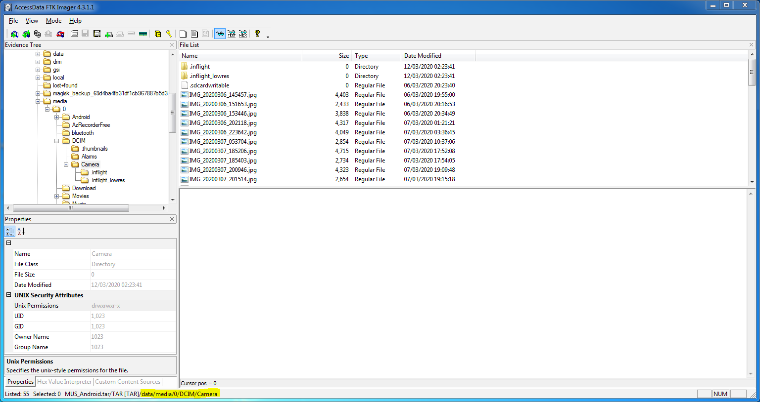
The next thing to stand out was the device media store – the photos and videos captured by the device camera – which can (but don’t always) contain location data in their EXIF metadata. I started with the default camera storage directory…
/data/media/0/DCIM/Camera
…and extracted a total of 53 images and videos using FTK Imager.
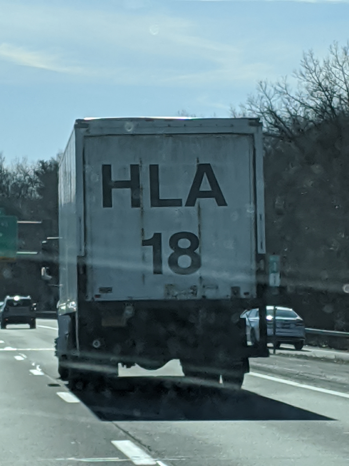
Switching to my SIFT virtual machine, based on the coordinates in the EXIF there were some nice photos taken in Norway, and a few around New York. There was nothing obviously related to cargo, but one photo showed a truck on what seems to be a US highway, with part of a signpost in the background. Trucks carry cargo, signposts point to exits. Curious.
The EXIF data for this photo contains GPS data:
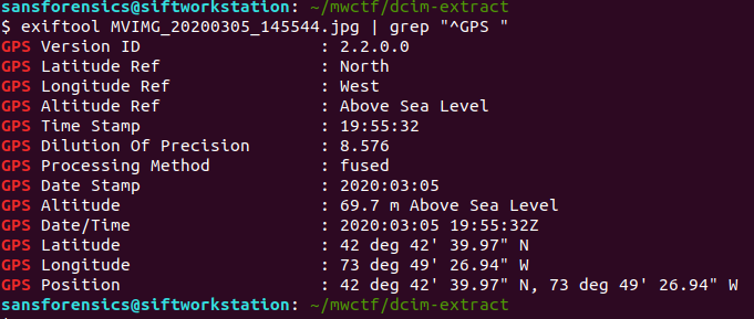
GPS Position: 42 deg 42' 39.97" N, 73 deg 49' 26.94" W
Massaging that to satisfy Google Maps, we can see that this photo was taken on Highway 87 north of Albany, New York.
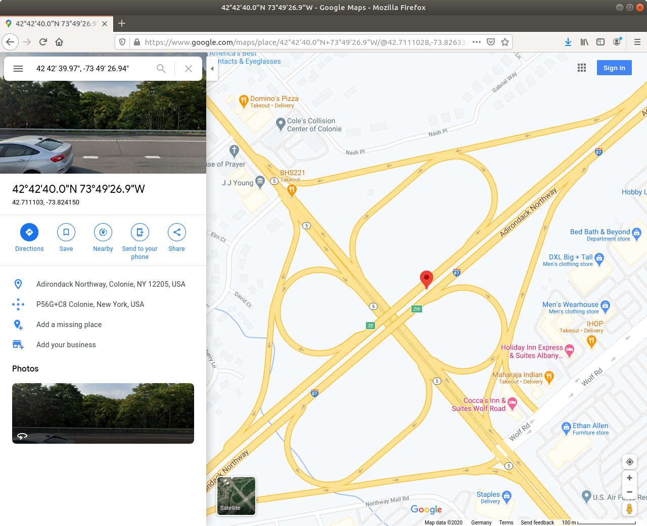
Dropping to Street View looks promising.
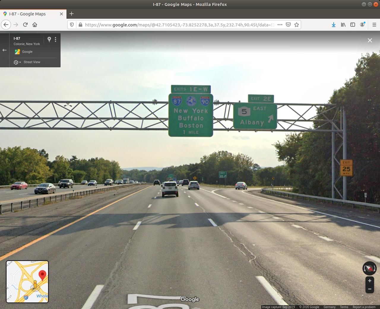
There we go! We have a photo of a cargo truck passing exit 2E. Week 3 done…

…or not.
One attempt down, two attempts left. Let’s think again.
The next artefact examined in the iOS/Android comparison presentation was Android Motion Photos. These are equivalent to iOS Live Photos and, in addition to taking a photo, records a video of roughly 1.5 seconds on either side of the photo capture.
Taking a closer look at the name of the truck photo, I noticed it is not IMG… but rather MVIMG… so we are indeed dealing with Motion Photos. This is the exact scenario Jessica Hyde sets out. We may not be able to see location details in the still image, but the video might show us something interesting. So how do we get to the video?
I found a great blog post outlining how Motion Photo files are structured, and put together a quick Bash script to extract the videos from our 8 Motion Photo files:
#!/bin/bash

INPUT_FILENAME="$1"
FILESIZE=$(stat -c%s "$INPUT_FILENAME")

MICRO_VIDEO_OFFSET=$(exiftool -MicroVideoOffset -s -s -s $INPUT_FILENAME)
OUTPUT_FILENAME=${INPUT_FILENAME%.*}

dd if="$INPUT_FILENAME" of="$OUTPUT_FILENAME.mp4" bs=$(($FILESIZE-$MICRO_VIDEO_OFFSET)) skip="1"
Essentially, we use exiftools to determine the Micro Video Offset value and subtract that from the filesize to find the start of the video data, then use the dd utility to skip the photo and write the video data to a new file. Running the script over each of the 8 Motion Photo file results in 8 short videos showing the second or so before and after each photo was captured.
I watched each video frame-by-frame using VLC and soon found what I was looking for in MVIMG_20200307_130326.jpg
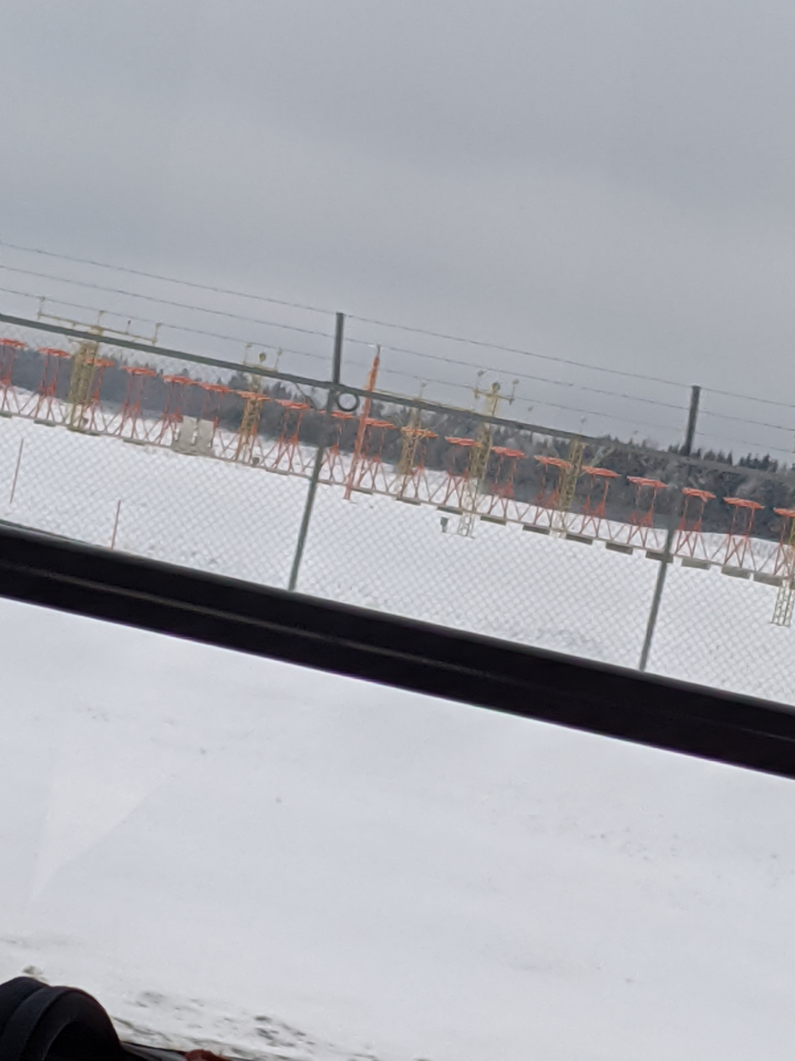
This photo was taken on the road approaching Oslo Airport, and moving through the embedded video frame-by-frame we can see a road sign directing cargo traffic via exit E (or maybe F) 16.
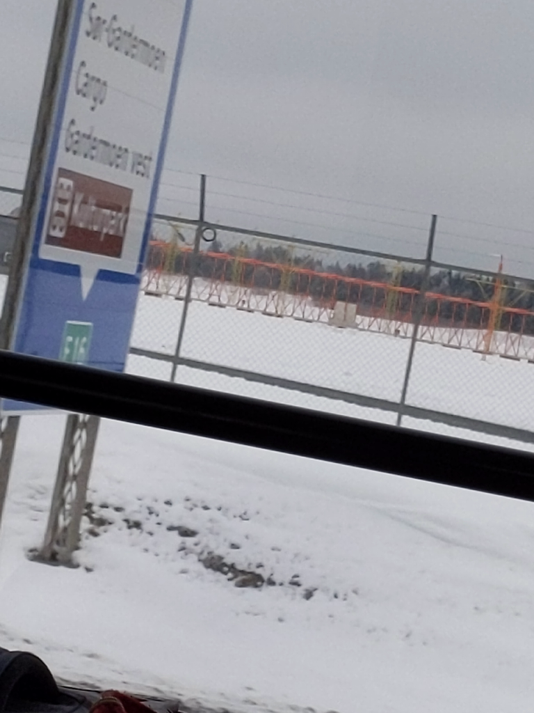
I could have used Google Maps and Streetview as before to confirm the answer, but I had two attempts left so tried E16 first, which was accepted. Week 3 Done!
Flag
E16
2 thoughts on “Magnet Weekly CTF – Week 3 – Cargo Hold”